
Sibbrett Point, Mt Cole State Forest - 12 Kms
U3A Hike No. 150


Links after the photos: Historical Notes, Track Notes, Interactive Map and GPX file download.

Hike Report by Geoff
It was a group of 10 who met at the Lucas car park in 8° temperature is Thursday morning. It was very helpful that Andrew had driven past Delacombe Town Centre on the way to check whether any of the group may have gone to the wrong starting point. It’s important to read the instructions on the correct starting point before each hike.
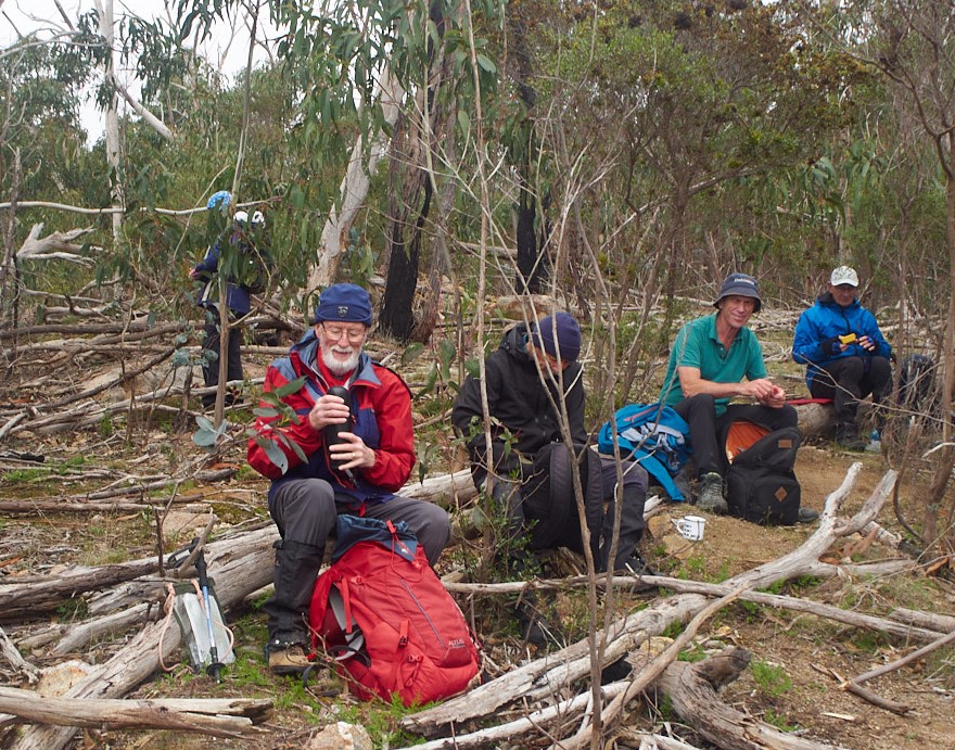
Despite the cool temperature Ian impressed/challenged us by wearing only a short sleeved top. The other group members remained rugged up. Although cool, conditions were overcast but dry and calm. It appeared that someone had advised that only women whose name starts with J could join us today because our female contingent consisted of Joan, Jan and Jane.
Our drive took us out to the Buangor exit on the Western Freeway, north, towards Warrak and the Mount Cole Road before parking on McGuiness Road. The drive took nearly an hour but were ready to start our walk at 9 am. Just before arriving at our end point, we slowed at a small gully where we spied a wedge tail eagle not far from the vehicles. On seeing us it took off and flew off within metres of our cars.
We walked for about five kms winding our way on an undulating track, past Ben Nevis and Sledging Point, around Collier Gap, along between The Pinnacles and Sibbrett Hill, eventually stopping for morning tea, 300 metres short of Sibbrett Point. This was a quite spectacular walk taking us past towering messmate trees and outcrops of granite boulders. Some Heath, still in flower, also fringed the track early on. We also passed several cuttings made through the hillside, presumably to allow for a tramway to carry timber that had been cut in earlier days.
While walking through one of these cuttings we found we had to climb out of the cutting because one of the older giants of the forest had recently come crashing down, blocking our way. In walking around the base of this fallen giant it was easy to see that as it had aged it had hollowed out and fire had further burnt out the hollow leaving only a few tenuous contact points with its root system. It didn’t take too much wind to bring the tree down.
Our morning tea site provided some views toward the Pyrenees and the plains below and at that time, sun shone through the clouds dappling the pastureland across the valley floor. We were able to watch several eagles above, plying the wind currents. After morning tea, we continued on, down a rough track with some steeper sections seriously eroded and other sections requiring us to divert around fallen trees. The sign on the gate at the top of the hill advising that the road was closed seemed quite unnecessary. It was undoubtedly no longer navigable by any vehicle, not even the toughest four-wheel drive, driven by the wildest hoon.
Eventually, we came out of the forest on to a point that gave us a vantage point over much of the land to the north, providing great views of the agricultural land below and across to the Pyrenees ranges.
It was only on our return journey when we retraced our steps that it started to rain and for much of the way, we walked in light but persistent rain. Andrew’s record of providing exceptional weather for our walks had come to an end. Rather than being daunted by this changed condition however, it meant that we were walking in an eerie mist, often losing sight of members of our group. Near one of the cuttings, one of our members deviated from the track to step behind a tree. On returning to the group, looming out of the mist, Andrew remarked that he thought we were seeing a yeti approaching. While others agreed that the site did appear abominable, we realised it was only Mark returning. Looking around at our group of mixed sizes and age shrouded in the mist while we made our way through the vegetation, I couldn’t help but thinking of that African movie featuring Sigourney Weaver. Can’t remember what it was called. (Movie was called Gorillas in the Mist).
It was a little after 1 o’clock by the time we return to our cars and we agreed to drive to Chainman’s picnic area where we could have our lunch under shelter. Trying to follow cars at this point was again made challenging in the mist, causing one of our group to drive off into the wilderness. Fortunately, we all met up again soon after, and found our way to Chinaman’s picnic area where we enjoyed our lunch, wishing we had time to light a fire in the fireplace within that shelter shed before returning to Ballarat.
We all agreed that this had been a very enjoyable walk to be recommended to others.
Thank you again Gordon.
Photos by Mark B 


Comments
Post a Comment